Last week started cold, got really warm once the weekend came and then ended on a chilly note. We are in a volatile weather period as a new pattern tries to establish itself over the region.
This is make it or break it time for the winter: If we don’t see a cold regime establishing itself over the area the next 10 days, chances are we will have below normal snowfall. Yes, we could get a lot of snow in February, but it will be hard to catch up. I will be watching this new pattern like a hawk to see if it will finally, if ever, deliver some winter weather.
This week will start cold once again, warm up enough to rain over the weekend and then cool back down to close out the week. It will be colder than last week, however.
Snow chances this week: There’s one major storm rolling in late Friday evening and lasting into Saturday, but it looks to be all rain for Philly. If that changes, I will let you know. Some ice may occur in the Poconos at the start. Flurries are possible on Monday, but it’s looking like no big deal at this point.
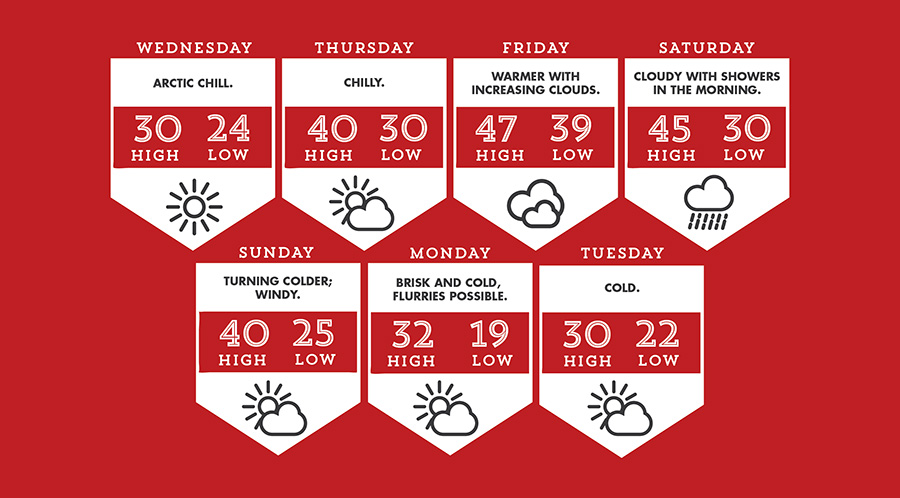
Wednesday starts our week in the icebox; brisk and cold as temperatures struggle to get to 30.
Thursday is a touch warmer as temperatures jump up to 40. It will still feel chilly though.
Friday gets even warmer, but we introduce clouds and showers in the late evening.
Saturday is rainy, especially in the morning. Temperatures will be in the 40s, so it’ll be chilly rain. Yuck.
Sunday is a transition day; it will start nice before a fresh shot of cold air comes dumping in the region.
Monday and Tuesday are all about the cold! Typical winter days with temperatures below freezing the entire time and wind chills making it feel colder.
The weather winner of the week is Friday; the weather loser is Tuesday.
Make sure to follow us on Twitter @TheSpiritNews for daily Penn’s Garden weather and forecast updates. Facebook: Accu-Reggie, Twitter: AccuReggie.